3D Handheld Scanning of Historic Buildings

The Project
For institutions of immense historical importance, regular upkeep is vital to preserve the structural integrity of the buildings.
The ability to map the intricate environments in detail is useful to identify faults and features, and to point out areas which require attention to protect them. How can the structural complexities of a medieval building be accurately catalogued within a limited time frame? The fully operational, busy academic establishment of Oriel College, part of the University of Oxford in the UK, forms a great challenge in this respect. This article gives insight into how a handheld mobile mapping tool with 3D simultaneous location and mapping (SLAM) technology was used to compile floor plans and elevation drawings of over 200 rooms in both a timely and a cost-effective manner.
Oriel College is blessed with alumni including two Nobel laureates, one of them being a founding member of the Oxford Movement (the Catholic revival in the Church of England). While the academic prowess of the college is not in any doubt, the structural integrity of an institution that was founded in 1326 is naturally less certain. Located in the heart of Oxford and made up of a myriad of buildings, with around 200 rooms across five storeys fulfilling a variety of uses, Oriel College presented unique scanning challenges.
The custodians of Oriel College needed to assess the physical ‘health’ of their ‘Island Site’, a hidden-away part of the college only usually accessible through two entrances, one of which is a tunnel with step access. The likelihood of encountering unforeseen issues with the buildings (particularly when a structure has been added to and developed over the years) was high. As such, accurate floor plans and elevation drawings needed to be created based on mobile mapping data, displaying exactly how the building was built.
This included all quirks and irregularities that are of interest for future structural improvements or changes to the buildings. A challenging handheld mobile mapping project was performed to create these maps and CAD drawings of this part of the University of Oxford.


TIME PRESSURE
The mobile mapping project was challenging not only due to the age and intricacy of the structures, but also due to the fact that the mapping needed to take place in as little time as possible to avoid disruption to daily operations. Meanwhile, it was important to obtain sufficient data without compromising on the accuracy of the results.
With some historical sites, it is possible to choose a time to scan when the buildings are closed to the public or not in use. Oriel College, however, is a world-class teaching, learning and research institution that has visitors, staff, students and alumni present at all times of day, all year round. In fact, many of the rooms would be in use during the scan as it was exam time, or serving as student accommodation with the associated privacy constraints. With over 40 fellows, 300 undergraduates and 160 graduates occupying the college, the mapping needed to be as swift as possible to minimise disruption.

UNCONVENTIONAL LAYOUT
Due to the unusual shape of the building, with its unconventional layout and complex network of rooms, it would prove difficult and time-consuming to survey with traditional static scanning methods (as this would require multiple individual set-ups and increased post-processing work). Added to the fact that static surveying methods can be more intrusive and require the team to stay significantly longer on site, it was also recognised that physically collecting data by measuring the space with traditional tools such as laser distance measurers or tape measures would not be suitable for Oriel College.

SLAM TECHNOLOGY
The chosen tool was the GeoSLAM ZEB-REVO, a handheld, lightweight, mobile indoor mapping tool that can record over 43,000 measurement points per second. The ZEB-REVO employs a very robust 3D simultaneous localisation and mapping (SLAM) algorithm, which is at its best in complex, enclosed, multi-level environments.
This SLAM technology utilises data from a Lidar sensor and an IMU to identify unique three-dimensional (3D) structures within the survey environment, and creates a point cloud of these structures. This iterative process occurs constantly as the user walks through the environment and builds up a 3D model of the space.
Since the ZEB-REVO unit contains an IMU, it does not require a GPS signal for positioning. As well as recording heritage buildings, the ZEB-REVO is used in other projects for generating footprints, estate agency requirements and scanning to building information modelling (BIM). Without the need for comprehensive training to use the device, the team was able to ‘pick up and go’ with the ZEB-REVO tool, saving additional preparation time for any members of staff previously unfamiliar with the technology.
The team’s previous experience indicated that GeoSLAM ZEB-REVO would significantly cut time and costs, while still reaching an average accuracy level of 15mm, making it a very suitable technology for this project.

RESULTS
Thanks to the scanner’s speed, the space could be surveyed in a very short amount of time, which was particularly important due to the limited time available in certain rooms. Using the ZEB-REVO around 200 rooms were scanned, amounting to 12,000m2 in total. Across five days, 12 individual rapid ZEB-REVO scans were completed, each taking around half an hour. Taking into account ten days to produce the CAD drawings, the entire project was completed in around half of the total time that would have been required using static equipment, reducing an estimated 44 days down to 24.
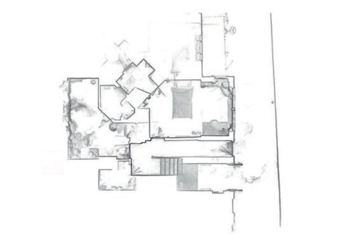
The final drawings were revelatory, showing just how irregularly the college buildings were arranged. As an institution with such a long history, it was also fascinating to discover how the college has been adapted and added to over time by different caretakers and building managers. Representing the buildings in their truest form (3D) made it possible to highlight the faults, features and fa ades that required attention or future planning to preserve.
NEXT STEPS
Using non-intrusive and accurate technology like the ZEB-REVO provides detailed accounts of a facility’s structural limitations. The next step in this project is the generation of complex BIM-ready 3D models from this 3D scan data. Such models can be used as a ‘digital twin’ of the building, allowing for building modifications and adaptations to be worked into the 3D model – either before or after the actual works have taken place. The use of geomatics technology has enabled the preservation of this historical institution from a heritage perspective, as well as ensuring that Oriel College can continue to provide education of the highest possible order for many years to come.
